King Tides and El Niño in Marin: When the Bay Floods, Where, and What It Means for Buyers
By Melissa DiVita, REALTOR®, Compass · DRE #01387955 · Fourth-generation Marin native, in real estate since 2003 · Updated November 17, 2026
Update, November 17: The first King Tides of the winter are next week, Tuesday through Thanksgiving Day, November 24–26, and the Bay is already running high. On November 13, high tide flooded the Mill Valley–Sausalito path, and forecasters expect the tides to start building around November 20. More rain may arrive Wednesday, November 18, and climate scientist Daniel Swain told KQED the second half of November could bring 2 to 10 inches of rain, with the King Tide periods through January a “very high concern” for coastal flooding. On November 12, NOAA said El Niño is still strengthening. If you’re near the Bay, this is the week to get sandbags and move things off the garage floor. The checklist is below.
The short answer: Marin’s King Tides this winter fall on November 24–26, December 23–25 and January 21–22, with the highest tide of the season on Christmas Eve morning. The places that flood first are the low spots along the Bay and its creeks: Manzanita near Tam Junction, Lucky Drive and the Greenbrae Boardwalk, the Larkspur and Corte Madera shoreline, Marin City, San Rafael’s Canal neighborhood, and North San Pedro Road near China Camp. This year a strong El Niño is raising sea levels and is likely to bring bigger storms, so a King Tide plus a storm is the combination to watch.
I’ve written about Marin’s microclimates, how fog, wind and sun can change from one hillside to the next. Water works the same way. Two homes a few blocks apart can have completely different flood stories, and in a winter like this one, that difference matters.
What a King Tide is
“King Tide” isn’t a scientific term. It’s what we call the highest tides of the year, which happen a few times each winter when the moon and sun line up and the moon is at its closest to Earth. They’re completely predictable, which is why the dates are known a year ahead. On a calm, dry day, a King Tide in Marin mostly means water over a few low roads, paths and parking lots. The trouble starts when something else piles on top.
2026–27 King Tide dates for the Bay Area
| Date | Peak (San Francisco) | Predicted height |
|---|---|---|
| Tue, Nov 24, 2026 | 10:05 a.m. | 6.94 ft |
| Wed, Nov 25, 2026 | 10:49 a.m. | 7.03 ft |
| Thu, Nov 26, 2026 (Thanksgiving) | 11:38 a.m. | 6.95 ft |
| Tue, Dec 22, 2026 | 8:56 a.m. | 7.01 ft |
| Wed, Dec 23, 2026 | 9:46 a.m. | 7.19 ft |
| Thu, Dec 24, 2026 | 10:37 a.m. | 7.23 ft (highest) |
| Fri, Dec 25, 2026 | 11:30 a.m. | 7.08 ft |
| Wed, Jan 20, 2027 | 8:44 a.m. | 6.96 ft |
| Thu, Jan 21, 2027 | 9:39 a.m. | 7.11 ft |
| Fri, Jan 22, 2027 | 10:33 a.m. | 7.09 ft |
| Sat, Jan 23, 2027 | 11:26 a.m. | 6.84 ft |
Statewide King Tide dates are from the California King Tides Project. Times and heights are NOAA predictions for the San Francisco gauge, in feet above mean lower low water. High tide reaches Richardson Bay, Corte Madera Creek and San Rafael a little later, so check NOAA for the station closest to you. The actual water level can run higher than predicted when there’s a storm or strong wind.
Where King Tides flood in Marin
Marin County lists these spots as places that have flooded during past King Tides:
- Mill Valley and Tam Junction: the Manzanita Park & Ride lot near Highway 1, and the Mill Valley–Sausalito path along Richardson Bay.
- Marin City.
- Tiburon: Greenwood Cove Drive along Richardson Bay.
- Greenbrae: Lucky Drive, and Redwood Highway at the Greenbrae Boardwalk.
- San Rafael: the Canal neighborhood, and North San Pedro Road through China Camp.
Last winter showed what happens when everything lines up. On January 2 and 3, 2026, King Tides arrived with more than 2 inches of rain and strong wind. KQED reported water spilling over levees in Corte Madera, Larkspur, Sausalito and San Rafael. Streets in the Larkspur Marina neighborhood along Corte Madera Creek turned into what the mayor called “a lagoon.” Highway 101 near Lucky Drive flooded, with exits closed for hours. In Santa Venetia, along Vendola Drive, residents worried about an aging berm.
I’ve lived this one myself. During one King Tide storm, the flooding in Larkspur was so bad I couldn’t drive there to pick up my son. That’s a detail no listing will mention, and it’s exactly the kind of thing that matters when you’re choosing where to live.
It can come down to which side of the street you’re on. In Paradise Cay in Tiburon, a waterfront neighborhood of lagoons and private docks, the south side of Jamaica and the north side of St. Lucia get water first. They can flood on an ordinary high tide, not just a King Tide, while nearby streets stay dry.
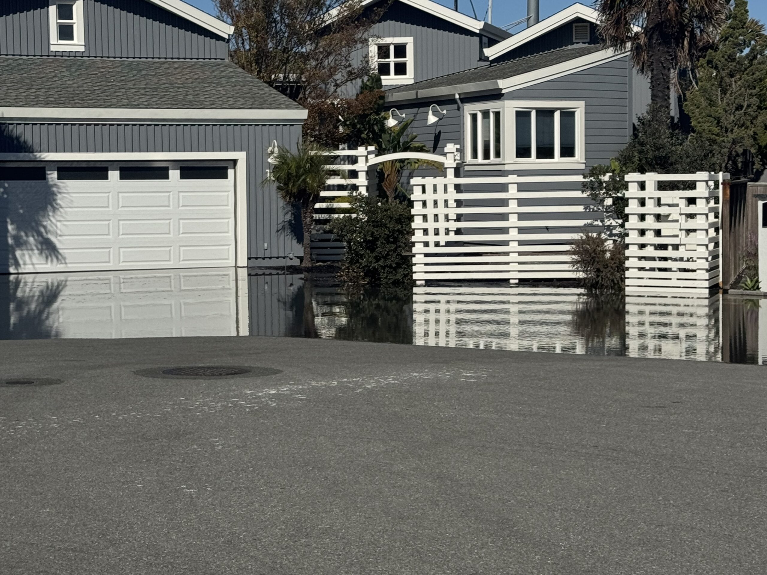
The pattern is what to take away. The low ground is mostly old marshland that was filled and built on: the shoreline along Richardson Bay, Corte Madera Creek and the San Rafael waterfront. Homes on the hillsides above, sometimes just a few streets away, never see the water.
Why rain plus a King Tide is the real problem
Much of low-lying Marin drains its rain into the Bay through creeks and storm drains. At an extreme high tide, those outlets are underwater, so the rain has nowhere to go and backs up into streets and yards. Add a storm’s low pressure and wind pushing water toward shore, and the Bay can rise above the predicted tide. That’s how last January’s flooding happened: rain, wind and a King Tide, all at once.
What El Niño is, and why this winter is different
El Niño is a warming of the Pacific Ocean near the equator that happens every few years. That warm water shifts the jet stream, which changes weather around the world. For California, it often means a stormier, wetter winter, though not always, especially in Northern California.
This year’s El Niño is a big one. On October 8, 2026, NOAA’s Climate Prediction Center reported the key ocean temperature reading 2.1°C above normal and still strengthening. Its November 12 update said El Niño is still getting stronger, with a better than 79% chance of a strong-to-very-strong event lasting through January–March 2027. Forecasters have said it could become one of the strongest on record.
For Marin’s shoreline, El Niño matters in two ways:
- Higher water to begin with. Warm water expands. Scripps Institution of Oceanography says a strong El Niño can raise sea level along the California coast by 6 to 13 inches. That sits on top of the tide, so every King Tide starts higher. Scripps also points out that this year’s strongest King Tides, around Christmas, line up with El Niño’s raised sea levels.
- Bigger storms and surf. El Niño winters tend to bring more storms and larger waves. On the Bay that means more rain arriving at high tide. On the coast, at Stinson, Bolinas and Point Reyes, it can mean beach erosion and bluff damage. During the 1997–98 El Niño, storm damage at one point closed 95% of the trails at Point Reyes National Seashore.
The Kelvin wave: why the Bay is already running high
This year there’s an extra piece. A strong El Niño sends what scientists call Kelvin waves across the Pacific. They aren’t waves you’d see or surf. They’re slow, wide bulges of warm water, miles across and invisible from shore, that cross the ocean, hit South America and then travel up the West Coast, raising sea level as they go. A strong El Niño usually brings several of them.
The first one reached California this month. Scientists told ABC7 in September that it could raise Bay Area sea levels by 6 to 12 inches, on top of water that was already running about 6 inches above normal. NC State oceanographer Dillon Amaya expects three or four more over the fall and winter, and said Bay Area water levels may not return to normal until spring 2027. Governor Newsom proclaimed a state of emergency in late September, and Sausalito set aside $250,000 for El Niño and flooding preparations.
That’s likely part of why the Paradise Cay streets in the photo above flooded on an ordinary October high tide. When the King Tides arrive in November, December and January, they’ll be starting from that higher water.
None of this means every low street will flood. It means the margin is thinner this winter, and the King Tide dates in the table above are the days to pay attention to the forecast.
If you’re buying in Marin
- Look up the flood zone. FEMA’s flood maps show whether a property sits in a Special Flood Hazard Area. Your Natural Hazard Disclosure report will say so too. If it does, and your loan is federally backed, flood insurance is required.
- Get a flood insurance quote before you write the offer, not after. My homeowners insurance guide covers how flood coverage works.
- Read the seller’s disclosures closely. Ask about past water in the garage or crawl space, sump pumps, sandbags and drainage work.
- Visit on a King Tide morning. Driving past a house you’re considering at high tide, especially in the rain, tells you more than any open house will.
- Think about the street, not just the house. A home can stay dry while the road to it floods. Check your commute route too; Highway 101 near Lucky Drive and Highway 1 at Manzanita are the usual trouble spots.
How to prepare for a King Tide
If you live on or near low ground by the Bay, a little preparation goes a long way. Here’s a simple checklist, from now through the day after.
Now, before the first King Tide on November 24
- Check your flood insurance. Regular homeowners policies don’t cover flooding. A new flood policy through the National Flood Insurance Program usually has a 30-day waiting period before it starts, so if you’re thinking about it, don’t wait until December.
- Get sandbags early. Marin County lists sandbag pickup sites on its emergency website, and they go fast once a storm is in the forecast.
- Clear gutters, downspouts, storm drains and driveway grates of leaves and debris, so rain can drain while it still has somewhere to go.
- Test your sump pump by pouring water into the pit, and think about a battery backup in case the power goes out in a storm.
- Get things off the garage floor. Put boxes, tools and anything you care about on shelves. Garages are usually the first place water comes in.
- Take photos of your garage, crawl space and belongings now, so you have a “before” record if you ever need to file a claim.
- Sign up for alerts at Emergency.MarinCounty.gov.
The week of a King Tide
- Check the tide time for your spot on NOAA’s tide predictions. The peak can arrive later in Richardson Bay, Corte Madera Creek and San Rafael than in San Francisco.
- Watch the weather forecast. A dry, calm King Tide is usually manageable. Rain or wind at the same time is the warning sign. Look for a Coastal Flood Advisory or Warning from the National Weather Service.
- Put sandbags in place at garage doors and low entry points the night before, not the morning of.
- Plan around the peak. Schedule errands, school pickups and appointments outside the high-tide window, and check 511.org for road closures before you leave.
On King Tide day
- Move your car to higher ground before the peak if your street floods. Bay water is salt water, and it’s hard on a car’s brakes, wiring and underside.
- Never drive or walk through floodwater. It’s often deeper than it looks and can carry debris and sewage. The county’s advice: “Turn Around, Don’t Drown.”
- Keep children and pets out of the water.
- Take photos or video at the peak. They’re useful for your own records, and the California King Tides Project collects photos to help plan for rising seas.
After the water goes down
- Rinse salt water off your car, garage floor and anything that got wet.
- Check the garage, crawl space and under the house for standing water, and dry things out quickly to head off mold.
- Document any damage with photos before you clean up, and call your insurance agent if you need to file a claim.
Why you want a realtor who knows the street on a gray day
Most homes in Marin are shown on a sunny afternoon, with the windows open and the Bay sparkling. That’s the house at its best. It isn’t the whole story. A listing won’t tell you that one side of a street takes on water at high tide, or that the road out of the neighborhood closes during a winter storm. A flood map helps, but it won’t tell you which driveway puddles every January.
That’s the kind of thing you learn by living here through a lot of winters. My family has been in Marin for four generations, and I grew up in Belvedere. When I take you to see a house near the Bay, I’ll tell you what that street looks like on a not-so-sunny day, and if you’re serious about it, we’ll go back and look at high tide.
Quick answers
When are the King Tides in Marin in 2026–27?
November 24–26, 2026, December 23–25, 2026 and January 21–22, 2027, with very high tides likely on December 22 and January 20 and 23 too. The highest is predicted for December 24, about 7.2 feet at the San Francisco gauge, late morning.
Where does Marin flood during King Tides?
Marin County lists the Manzanita Park & Ride near Tam Junction, the Mill Valley–Sausalito path, Marin City, Greenwood Cove Drive in Tiburon, Lucky Drive and the Greenbrae Boardwalk, San Rafael’s Canal neighborhood and North San Pedro Road at China Camp. In January 2026, a King Tide with heavy rain also flooded parts of Larkspur and Corte Madera.
Does El Niño make King Tide flooding worse?
It can. A strong El Niño can raise California sea levels by 6 to 13 inches, according to Scripps, and often brings more storms. Rain arriving at a King Tide can’t drain into the Bay, which is when low areas flood.
Is there an El Niño in winter 2026–27?
Yes. NOAA’s Climate Prediction Center has an El Niño Advisory in effect, and its November 12, 2026 update said El Niño is still strengthening, with a better than 79% chance of a strong-to-very-strong event through January–March 2027.
How do I prepare for a King Tide in Marin?
Check your flood insurance early, since new National Flood Insurance Program policies usually have a 30-day wait. Get sandbags from a Marin County pickup site, clear gutters and drains, test your sump pump and get things off the garage floor. The week of the tide, check NOAA tide times and the forecast, and put sandbags in place the night before. On the day, move your car to higher ground and never drive or walk through floodwater.
What is the Kelvin wave, and does it affect Marin?
A Kelvin wave is a slow, wide bulge of warm water that El Niño sends across the Pacific and up the West Coast. It isn’t visible and doesn’t break like a surf wave, but it raises sea level. Scientists said this fall’s Kelvin wave could add 6 to 12 inches to Bay Area water levels, with more expected through winter, which makes King Tides and storm flooding more likely in low-lying parts of Marin.
Sources
- California King Tides Project (California Coastal Commission)
- NOAA Tides & Currents: San Francisco station 9414290
- Marin County: seasonal King Tides and known flood locations
- KQED: Marin County looked like a lagoon after King Tides and heavy rain (January 2026)
- NOAA Climate Prediction Center: ENSO diagnostic discussion
- Scripps Institution of Oceanography: how El Niño affects the California coast
- ABC7: El Niño-driven Kelvin wave could raise Bay Area sea levels by up to 1 foot (September 2026)
- AP / PBS NewsHour: what to know about the Kelvin wave raising West Coast sea levels (October 2026)
- FEMA Flood Map Service Center
About the author: Melissa DiVita grew up in Belvedere, her family has been in Marin for four generations, and she lives in Tiburon. She has been a REALTOR® since 2003 and works with Compass in Tiburon. This is general information, not insurance or engineering advice.
Wondering about a specific street? Send me a note. I’m happy to tell you what I know about how a neighborhood handles winter, before you fall in love with a house.